8 min read
Surveyors.io Editorial
Wetland delineation North Carolina cost and what still needs a permit after the 2023 Farm Act
Oct 20, 2026 · 8 min read
The price range and turnaround for the job you describe appear here.
Traverse
Estimate for ,
typical local range · on site to drawing
A published range for this type of work, not a quote. Send the request and surveyors listed for your county reply with their own price.
Free for clients · You choose who to talk to
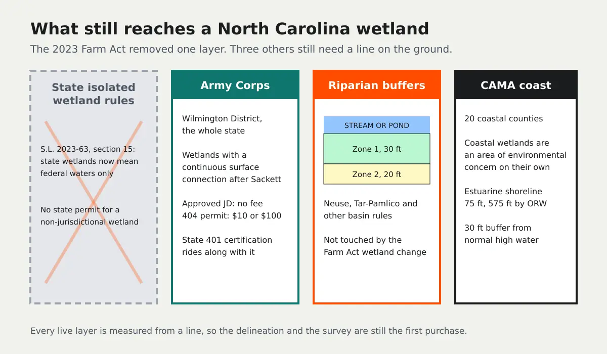
A wetland delineation in North Carolina costs about $2,500 to $4,500 on a parcel under two acres, $4,000 to $6,000 at five acres and $6,000 to $14,000 on a 10 to 20 acre tract, and a licensed land surveyor's map of the flagged line adds $1,200 to $4,000. The 2023 Farm Act took away the state's own protection for wetlands the federal government no longer regulates. It did not take away the Army Corps, the 50 foot riparian buffer rules or the coastal CAMA rules, and all three still start with a line on the ground.
That is why "North Carolina dropped its wetland rules" is the most expensive half truth a landowner or builder in this state can act on. The useful question is which of the remaining regulators reaches your parcel, and whether you can prove it does not before you clear, grade or close.
How much does a wetland delineation cost in North Carolina?
Consultants price the field and report work by acreage and by how hard the wet to dry transition is to read. Coastal plain pocosins and pine flats in the east are slow to walk and hard to call; a Piedmont lot with one wet swale is quick. The method is the same statewide: a desktop review of soils maps, the National Wetlands Inventory and aerials, then field data on vegetation, soils and hydrology at sampling points, flags on the boundary and a report to the Corps manual and the regional supplement.
| What you are buying | Typical North Carolina cost | Who you pay |
|---|---|---|
| Delineation and report, under 2 acres | $2,500 to $4,500 | Wetland consultant |
| Delineation and report, about 5 acres | $4,000 to $6,000 | Wetland consultant |
| Delineation and report, 10 to 20 acres | $6,000 to $14,000 | Wetland consultant |
| Large or complex tract, about 40 acres | $18,000 to $28,000+ | Wetland consultant |
| Survey of the flagged line and the stream buffers against your deed lines | $1,200 to $4,000 | North Carolina licensed land surveyor |
| Support for an approved jurisdictional determination | $1,500 to $5,000 | Wetland consultant |
| Corps jurisdictional determination; Section 404 individual permit | Free; $10 non-commercial or $100 commercial | Army Corps, Wilmington District |
| Riparian buffer determination (example: Johnston County) | $500 for one or two site calls, $125 each additional | Local buffer authority |
Those consultant figures are market ranges. We did not find a published North Carolina price for a delineation, from a consultant or from a public contract, so treat any quote well outside them as a reason to ask what is in the scope. The two public numbers in the table are real. Under 33 CFR 325.1(f) the Corps charges $10 or $100 for an individual permit, nothing for general permits and nothing for a jurisdictional determination. Johnston County, which administers the Neuse buffer rule locally, charges $500 for one or two site calls before a buffer determination and $125 for each extra call, and its request form says a wetland delineation should be completed at the site first.
What the 2023 Farm Act changed
Section 15 of the 2023 Farm Act (Session Law 2023-63) rewrote the state definition so that wetlands classified as waters of the State are restricted to waters of the United States. The legislature passed it over the governor's veto and the change took effect immediately. In plain terms, a wetland that is not federally jurisdictional no longer needs a state permit to fill. That makes the state's isolated wetland rules in 15A NCAC 02H .1300 a dead letter in practice, and it landed weeks after the Supreme Court's Sackett decision narrowed the federal definition, so the two cuts stacked.
The Environmental Management Commission voted 10 to 5 in September 2025 to write the same definition into its water quality rule, 15A NCAC 02B .0202. Under the Farm Act that rule cannot take effect until the General Assembly reviews it, which was expected in the 2026 session, and we found no confirmation that it has happened. The statute already controls either way, so for a 2026 project the practical rule is the same: the state regulates only the wetlands the Corps regulates.
Do I still need a wetland delineation in North Carolina?
Yes, whenever a wetland or stream could be close to the work, because every regulator that is left measures from a line. A delineation is how you show the Corps a wet area is isolated and outside its reach, how you set the start of a stream buffer, and how you find the edge of a coastal wetland. Skipping it does not make the wetland non-jurisdictional. It only means you find out from an enforcement letter instead of a report.
After Sackett, the Corps regulates wetlands with a continuous surface connection to a relatively permanent water. Plenty of North Carolina wetlands still meet that test, especially along streams, rivers and sounds. If yours does, filling it needs a Section 404 permit, and the state 401 water quality certification comes with it. The Wilmington District covers the whole state, and the same delineation report done to the Corps manual serves the federal and state review.
The riparian buffer rules the Farm Act did not touch
The Neuse (15A NCAC 02B .0714) and Tar-Pamlico (.0734) rules, and the similar rules in other basins, protect a 50 foot buffer beside streams, ponds, lakes and estuaries. The inner 30 feet, Zone 1, stays undisturbed forest; the outer 20 feet, Zone 2, can be managed vegetation with periodic mowing. The rules apply to water bodies shown on the NRCS soil survey or the USGS 1:24,000 topographic map, and the buffer is measured from the top of the bank, or from the normal water level for a pond or lake. Activities are deemed allowable, allowable with authorization, allowable with mitigation, or prohibited, and anything not listed is prohibited.
None of that depends on the wetland definition. A builder who reads "the state dropped wetland rules" and grades to the edge of a mapped intermittent stream can still be in violation of the buffer rule, and the buffer often takes more of a lot than the wetland does. A surveyor locating the top of bank and the 30 and 50 foot lines on the site plan is what keeps the house pad and the drainfield out of it.
On the coast, CAMA still decides
In the 20 coastal counties, the Coastal Area Management Act adds another layer that has nothing to do with the Farm Act. Coastal wetlands are an area of environmental concern defined by tidal flooding and the presence of listed marsh plants. The estuarine shoreline area runs 75 feet landward from normal high water, or 575 feet beside Outstanding Resource Waters, and public trust shorelines carry a 30 foot buffer in which most new building is barred. Minor permits come from the local government, general permits for routine work such as docks and bulkheads from Division of Coastal Management field staff, and major permits from the Morehead City office after review by several agencies. Every one of those lines is drawn from a surveyed normal high water or coastal wetland line.
Why the surveyed line is the part you will reuse
The delineator decides where the wetland is. A North Carolina Professional Land Surveyor, licensed by the Board of Examiners for Engineers and Surveyors, puts that decision on your parcel: ties the flags to the deed lines, draws the wetland, the stream top of bank, both buffer zones and any CAMA line on one sealed drawing, and gives the site plan real coordinates. That drawing is what the Corps reviews, what the buffer authority checks and what a buyer's lender will ask for.
If you are buying land, the line belongs in the contract, not after it. Make the purchase contingent on the delineation and the buffer determination, and give yourself a due diligence period long enough for both, because a Corps answer that arrives after your contingency expires buys you nothing. Builders juggling several parcels tend to track the contingency deadlines in each purchase contract the same way they track closing dates.
How long does a North Carolina wetland delineation take?
The field visit is usually one or two days on a small parcel and the report two to four weeks, with the survey running alongside. A Corps jurisdictional determination and a buffer site call add their own queues. Season matters less in the coastal plain than up north, but a dry late summer can hide hydrology and a wet winter can exaggerate it, so a careful consultant will say which way the conditions cut. If you need a permit in spring, book the delineation in the fall before.
How to keep a North Carolina delineation inside budget
Before you buy, check the parcel against the National Wetlands Inventory, the NRCS soil survey and the USGS topographic map, because the last two also decide where buffer rules apply. Ask the county or town whether it administers the buffer rule locally and what it charges for a site call. On the coast, call the local CAMA officer. Then hire one consultant to delineate to the Corps manual so the report serves every agency, and put a surveyor on the same calendar so the flags are located before they fade.
Describe the parcel once above and we will match you with up to three licensed surveyors who work your county and coordinate with wetland consultants. For the national price picture see wetland delineation cost, for the consultant side the wetland delineation services page, and for a Gulf state with its own coastal permit the Louisiana wetland delineation cost guide. Local surveyor coverage is on land surveyors in North Carolina.
Need it done right? Send one scoped request to licensed land surveyors near you and compare what they quote. Free for clients.