9 min read
Surveyors.io Editorial
Wetland delineation cost Louisiana landowners pay, with coastal use permit fees and Corps rules
Oct 12, 2026 · 9 min read
The price range and turnaround for the job you describe appear here.
Traverse
Estimate for ,
typical local range · on site to drawing
A published range for this type of work, not a quote. Send the request and surveyors listed for your county reply with their own price.
Free for clients · You choose who to talk to
A wetland delineation in Louisiana costs about $2,500 to $4,500 on a parcel under two acres, $4,000 to $6,000 at five acres and $6,000 to $14,000 on a 10 to 20 acre tract, with a surveyed plat of the flagged line adding $1,200 to $4,000. The state's own fees are small: a residential coastal use permit application is $20. The real money in Louisiana is mitigation, which a consulting firm puts at $20,000 to $40,000 per credit inland and $60,000 to $100,000 per credit on the coast.
So the delineation is not the expensive part. It is the part that decides how expensive everything after it will be. A line drawn tight and documented to the Corps' New Orleans District standard can keep a house pad, a driveway or a commercial building out of the wetland entirely. A loose one, or one nobody located on the ground, turns into a mitigation bill or a second field day. Below is what each piece costs in Louisiana in 2026 and who reviews it.
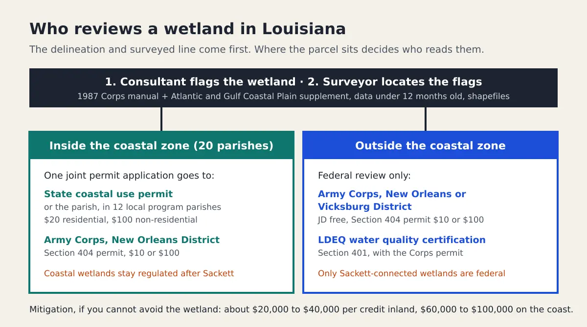
How much does a wetland delineation cost in Louisiana?
The field and report work prices the same way it does nationally, by acreage and complexity. Louisiana tracts lean toward the expensive end of each band for two reasons. Bottomland hardwood and pine flatwood sites have gradual, hard-to-read transitions between wet and dry ground, so the consultant digs more soil pits per acre. And the regional supplement the Corps uses here notes that soils in Louisiana bottomland hardwood forests stay biologically active essentially all year, which removes the seasonal shortcuts a delineator might use farther north.
| What you are buying | Typical Louisiana cost | Who you pay |
|---|---|---|
| Delineation and report, under 2 acres | $2,500 to $4,500 | Wetland consultant |
| Delineation and report, about 5 acres | $4,000 to $6,000 | Wetland consultant |
| Delineation and report, 10 to 20 acres | $6,000 to $14,000 | Wetland consultant |
| Large or complex tract, about 40 acres | $18,000 to $28,000+ | Wetland consultant |
| Survey of the flagged line, plat against your deed lines | $1,200 to $4,000 | Louisiana licensed land surveyor |
| Preparing and supporting an approved JD request | $1,500 to $5,000 | Wetland consultant |
| Re-delineation after the data goes stale | 50% to 100% of the original | Wetland consultant |
These are market ranges for 2026, not quotes. Ask every consultant to price the surveyed plat as its own line, because a low bid that leaves out the survey is not a low bid. The national wetland delineation cost breakdown explains each deliverable in more detail.
What does Louisiana charge in permit fees?
Very little, and that surprises people. The coastal use permit fee schedule sits in the Louisiana Administrative Code at LAC 43:I.723, and it scales with how much material you move, not with the wetland acreage.
| Fee | Residential | Non-residential |
|---|---|---|
| Coastal use permit application | $20 | $100 |
| Request for determination (is a permit needed?) | $20 | $100 |
| Volume of material disturbed | None under 125 cu yd, then $0.04 per cu yd | $25 under 500 cu yd, then $0.05 per cu yd |
| Volume fee cap | $2,000 at 50,000 cu yd or more | $5,000 at 100,001 cu yd or more |
| Corps Section 404 permit (33 CFR 325.1) | $10 non-commercial | $100 commercial |
If your project cannot avoid a coastal wetland, LAC 43:I.724 adds a mitigation processing fee on top: $50 for non-commercial work affecting one acre or less of vegetated wetland, and for everything else a sliding scale from $150 (up to half an acre) and $300 (half an acre to one acre) up to $2,250 at 5 to 10 acres and $15,000 above 100 acres. That fee is for processing. The mitigation itself is bought separately, either as credits from a mitigation bank or as a payment into the state's Coastal Mitigation Account, and that is where five-figure numbers appear.
Is my property in the Louisiana coastal zone?
It is if it lies inside the inland boundary set by La. R.S. 49:214.24, which was last redrawn by Act 588, effective June 7, 2012. Twenty parishes have land in the zone: Ascension, Assumption, Calcasieu, Cameron, Iberia, Jefferson, Lafourche, Livingston, Orleans, Plaquemines, St. Bernard, St. Charles, St. James, St. John the Baptist, St. Martin, St. Mary, St. Tammany, Tangipahoa, Terrebonne and Vermilion. Several of those parishes are only partly inside, so check the boundary map for your parcel rather than the parish name.
Twelve coastal parishes run approved local coastal programs and act as the permitting authority for uses of local concern: Calcasieu, Cameron, Jefferson, Lafourche, Orleans, Plaquemines, St. Bernard, St. Charles, St. James, St. John the Baptist, St. Tammany and Terrebonne. They may set their own fees. For a house lot or small commercial pad, that often means your coastal use permit comes from the parish, while the federal side still goes to the Corps.
One administrative change matters if you are reading older guidance. The Department of Natural Resources became the Department of Energy and Natural Resources in 2024, and on October 1, 2025 it was reorganized again into the Department of Conservation and Energy, with the coastal permitting that used to sit in the Office of Coastal Management folded into a centralized permitting office. The fee rules above did not change with the name.
Will the Corps of Engineers delineate my wetland for free?
Usually not, and planning around it costs months. The New Orleans District's own delineation report requirements say it is not usually feasible for the district to complete a wetland delineation for a jurisdictional determination on property larger than five acres, and that applicants should hire an independent wetland consultant. The district also says it receives well over a thousand JD requests in an average year. A 2016 Corps guidance letter (RGL 16-01) lets districts put stand-alone JD requests, the ones not tied to a permit application, behind permit work, and in September 2025 the New Orleans District issued a special public notice on exactly that discretionary workload. Ask about current intake before you plan a closing around a JD.
The Corps charges no review fee for a jurisdictional determination; its fee rule covers permits only. What you pay for is the consultant's work to produce a package the district will accept the first time.
What does the New Orleans District require in a delineation report?
The district asks for a delineation done under the 1987 Corps Wetland Delineation Manual and the Atlantic and Gulf Coastal Plain Regional Supplement, Version 2.0, which covers essentially all of Louisiana. Its written requirements add three things that drive cost. The field data can be no older than twelve months. The wetland boundary has to be flagged in the field. And the boundary has to be delivered as GIS shapefiles. Requests go in through the Corps' Regulatory Request System or by email with ENG Form 6247, a map in the style of a survey plat and a vicinity map.
The twelve-month rule is the one that bites. If the flags go in during a spring due diligence period and the JD request goes in after the holidays, the data may already be stale and you pay for a re-delineation. Have a surveyor locate the flags while they are still standing, and file promptly. Parts of north Louisiana fall under the Corps' Vicksburg District instead, which has its own Louisiana branch; confirm which district covers your parcel before your consultant formats the report.
How long is a Louisiana wetland determination good for?
An approved jurisdictional determination from the Corps is valid for five years under Corps guidance, and you can appeal it. A preliminary JD is advisory, has no appeal rights, and simply treats the mapped waters as if they were jurisdictional, which is often faster and good enough when you plan to avoid the wetland or are applying for a permit anyway. A delineation report with no agency sign-off has no legal expiry, but the New Orleans District will not accept field data older than a year for a new request.
Did Sackett change what needs a delineation in Louisiana?
It narrowed what counts as a federally regulated wetland, but it did not remove the need to delineate. After the Supreme Court's 2023 decision in Sackett v. EPA, a wetland must have a continuous surface connection to a covered water to fall under the Clean Water Act. Louisiana is one of the states where the amended 2023 rule does not apply because of litigation, so the Corps applies the pre-2015 regime read consistently with Sackett. EPA and the Army proposed a new definition on November 20, 2025 and a supplemental proposal on September 4, 2026, with no final rule yet. And none of this touches the state coastal use permit, which regulates coastal wetlands under state law whether or not they are federal waters. The only way to know which side of the line your project falls on is a delineation.
Who should do the work, a consultant or a surveyor?
Both, for different parts. A wetland scientist reads the soils, vegetation and hydrology and decides where the boundary is. A Louisiana licensed land surveyor then locates those flags and draws them against your property lines, which is what an engineer needs to fit a building pad and what a lender or buyer needs to see how much of the parcel is usable. The New Orleans District only requires that its map be approved by the field personnel who collected the data, so a sealed plat is your choice rather than the Corps' rule. On anything you plan to build on, sell or finance, it is worth paying for. You can check any surveyor's license in the LAPELS licensee search at lapels.com before you hire.
If you are buying land, the delineation also feeds the price you should pay. Usable acreage, not total acreage, is what a buyer should value, and a quick land valuation run on the dry portion alone often shows how much the wetland is really costing the seller's asking price.
How to keep a Louisiana delineation inside budget
Screen the parcel against the soil survey and the National Wetlands Inventory first, so you know whether you are buying a five-acre job or a forty-acre one. Ask for a request for determination ($20 residential) if you are not sure the coastal use permit applies. Get the consultant and the surveyor on the same calendar so the flags are located while they stand. File the JD package inside the twelve-month window. And price mitigation before you close, not after the design is fixed, because that is the line that can outgrow everything else on this page combined.
Describe the parcel once above and we will match you with up to three licensed surveyors who work your parish and coordinate with wetland consultants. For how to vet the consultant side, see our wetland delineation services page. If your Louisiana project also sits in a flood zone, the elevation certificate Louisiana guide prices the other survey you are likely to need, and for a coastal state with a very different permit structure compare wetland delineation cost in Florida.
Need it done right? Send one scoped request to licensed land surveyors near you and compare what they quote. Free for clients.