8 min read
Surveyors.io Editorial
Wetland delineation cost Minnesota landowners pay, with the WCA boundary decision and the survey it needs
Oct 14, 2026 · 8 min read
The price range and turnaround for the job you describe appear here.
Traverse
Estimate for ,
typical local range · on site to drawing
A published range for this type of work, not a quote. Send the request and surveyors listed for your county reply with their own price.
Free for clients · You choose who to talk to
A wetland delineation in Minnesota costs about $2,500 to $4,500 on a parcel under two acres, $4,000 to $6,000 at five acres and $6,000 to $14,000 on a 10 to 20 acre tract, and a licensed surveyor's map of the flagged line adds $1,200 to $4,000. Minnesota layers its own Wetland Conservation Act on top of the federal program, so the line is approved locally by a city, county, watershed district or soil and water conservation district. That boundary decision is valid for five years, and the statute names survey mapping as part of the proof you submit.
So the practical question for a Minnesota lot is not only what the delineator charges. It is whether the package you hand the local government unit is complete enough to approve the first time, because a boundary decision is what your city or county will hang the building permit, the plat or the septic design on.
How much does a wetland delineation cost in Minnesota?
The field and report work is priced the way it is nationally, by acreage and by how hard the wet to dry transition is to read. Minnesota sites are often at the harder end: glacial soils, shallow depressions and old drainage tile make the boundary less obvious than the aerial photo suggests, and the delineator has to dig more soil pits and fill out more data forms before the line holds up.
| What you are buying | Typical Minnesota cost | Who you pay |
|---|---|---|
| Delineation and report, under 2 acres | $2,500 to $4,500 | Wetland consultant |
| Delineation and report, about 5 acres | $4,000 to $6,000 | Wetland consultant |
| Delineation and report, 10 to 20 acres | $6,000 to $14,000 | Wetland consultant |
| Large or complex tract, about 40 acres | $18,000 to $28,000+ | Wetland consultant |
| Survey of the flagged line, mapped against your deed lines | $1,200 to $4,000 | Minnesota licensed land surveyor |
| Preparing and supporting an approved JD request | $1,500 to $5,000 | Wetland consultant |
| WCA boundary or type application | Set by each LGU, and some charge nothing | City, county, watershed district or SWCD |
| Corps jurisdictional determination itself | No fee | Army Corps, St. Paul District |
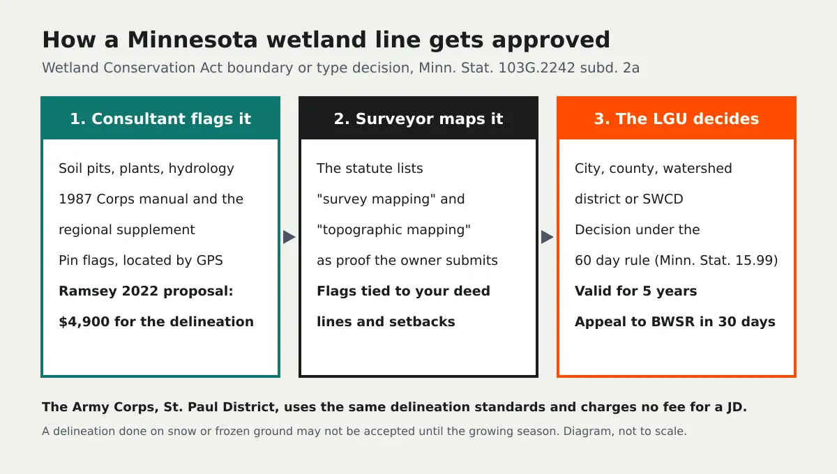
Those are market ranges, not published rates. One public data point is worth having because it shows the line items. In a September 22, 2022 proposal to the City of Ramsey, Bolton & Menk priced a Level II aquatic resource delineation of the city's COR redevelopment area at $4,900, with a historical analysis of whether each wetland was incidental at $1,800 and agency meetings and extra requests at $1,100, for a not-to-exceed total of $7,800. The scope placed 3 foot pin flags at the wetland limits and located each one with a sub-meter GPS unit. Note what that last step is and is not. It is good enough to draw the wetland on a map. It is not a survey tied to your property corners.
Who approves a wetland boundary in Minnesota?
The local government unit that administers the Wetland Conservation Act where your land sits. That is usually the city, sometimes the county, a watershed district or watershed management organization, or a soil and water conservation district. Minnesota Rule 8420.0310 lets a landowner apply to that LGU for a wetland boundary or type decision on its own, or as part of an exemption, no-loss, sequencing or replacement plan application, and an approved boundary can be carried into the later application while it is still valid.
The process sits in Minn. Stat. 103G.2242, subdivision 2a. Three details there matter to your budget:
- The proof is your job. The landowner is "responsible for submitting proof necessary to make the determination, including, but not limited to, wetland delineation field data, observation well data, topographic mapping, survey mapping, and information regarding soils, vegetation, hydrology, and groundwater."
- The decision follows the 60 day rule. The LGU decides under Minn. Stat. 15.99, which is the 60 day deadline for agency action on a written request, and it must send the decision within ten days to you, the Technical Evaluation Panel, the watershed district and anyone who asked.
- It lasts five years. The decision "is valid for five years unless the Technical Evaluation Panel determines that natural or artificial changes to the hydrology, vegetation, or soils of the area have been sufficient to alter the wetland boundary or type."
If you disagree with the decision, subdivision 9 lets you petition the Board of Water and Soil Resources within 30 days of the mailing, with a filing fee the statute caps at $1,000. Miss the 30 days and the decision is final.
What the LGU charges to review the application is local. The Ramsey-Washington Metro Watershed District, for example, says it "does not currently have fees associated with WCA application submittals." Ask your LGU before you budget, and ask whether it wants the boundary decision before or alongside the building permit.
Why the survey is part of the proof
The delineator decides where the wetland is. A licensed land surveyor puts that decision on your parcel: ties the flags to the deed lines, shows the wetland, any buffer your city adds and the setbacks from the building code on one sealed drawing, and gives the plat or permit drawing real coordinates. That is the "survey mapping" the statute names. Under Minn. Stat. 326.02 only a licensed land surveyor may practice land surveying in Minnesota, so a consultant's GPS sketch can show the wetland but cannot fix where your property line is relative to it.
On sloped or rolling ground the "topographic mapping" piece also earns its cost. Contours explain where water collects, they support the hydrology argument in the report, and they show the builder where the house pad and driveway can go without grading into the buffer. A surveyor's topographic survey is the version a city engineer will review; for early planning across a large site, a drone topographic map of the whole property can show the drainage pattern before you pay for ground survey on the part that matters. Our topographic survey page covers what the ground version costs.
Do I also need the Army Corps?
Only if you plan to discharge fill into waters of the United States, but most Minnesota owners deal with both programs at once. The Board of Water and Soil Resources says that WCA and the St. Paul District of the Corps "utilize the same standards, resources and methodologies": the 1987 Corps of Engineers Wetlands Delineation Manual and the regional supplement for the land resource region where the site sits. One good delineation report can serve both agencies.
The federal fees are small. Under 33 CFR 325.1(f) an individual Section 404 permit costs $10 for a non-commercial project and $100 for a commercial one, general permits carry no fee, and a jurisdictional determination is free. An approved JD under 33 CFR 331.2 can be appealed; a preliminary JD is advisory and treats the wetlands as jurisdictional. Since the Sackett decision some wetlands that are not federal waters are still wetlands under WCA, so a federal "no jurisdiction" letter does not end the Minnesota question.
How long does a Minnesota wetland delineation take?
The field visit is usually one or two days on a small parcel and the report another two to four weeks with the survey running alongside. The LGU then has 60 days under the state rule, and longer if it extends the deadline in writing. The season is the bigger variable. Soils, vegetation and hydrology are read in the field, and work on snow cover or frozen ground can be deferred until the growing season or treated as provisional by the reviewer. If you want a spring permit, book the delineator for the previous summer or early fall.
How to keep a Minnesota delineation inside budget
Check the National Wetlands Inventory, the county soil survey and your city's wetland map before you buy, so you know whether you are pricing a two acre job or a forty acre one. Ask the LGU three questions: does it want a boundary decision or only a report, what does it charge, and does the city add a buffer. Hire a delineator from the BWSR wetland professional certification list and put the surveyor on the same calendar, so the flags are located before the snow. Then lay out the house, the drive and the septic around the approved line, and remember the approval lasts five years: if you are platting in phases, time the later phases inside that window.
Describe the parcel once above and we will match you with up to three licensed surveyors who work your county and coordinate with wetland consultants. For the national price picture see wetland delineation cost, for the consultant side the wetland delineation services page, and for neighboring states the Wisconsin and Michigan guides. Local surveyor coverage is on land surveyors in Minnesota.
Need it done right? Send one scoped request to licensed land surveyors near you and compare what they quote. Free for clients.