8 min read
Surveyors.io Editorial
Wetland delineation cost Alabama landowners pay, with Baldwin County setbacks and ADEM fees
Oct 13, 2026 · 8 min read
The price range and turnaround for the job you describe appear here.
Traverse
Estimate for ,
typical local range · on site to drawing
A published range for this type of work, not a quote. Send the request and surveyors listed for your county reply with their own price.
Free for clients · You choose who to talk to
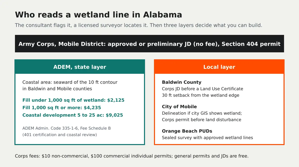
A wetland delineation in Alabama costs about $2,500 to $4,500 on a parcel under two acres, $4,000 to $6,000 at five acres and $6,000 to $14,000 on a 10 to 20 acre tract, and a licensed surveyor's plat of the flagged line adds $1,200 to $4,000. Alabama has no state wetland permit of its own, but on the Gulf coast the rules around the delineation cost more than the delineation: Baldwin County requires an Army Corps jurisdictional determination before it issues a land use certificate in its wetland overlay, holds development 30 feet back from the wetland edge, and the Alabama Department of Environmental Management (ADEM) charges $2,125 to review a fill of less than 1,000 square feet of wetland.
So the useful question is not only what the consultant charges. It is how tight a line you can defend, because every foot of wetland the line takes off your buildable area also takes 30 more feet of setback with it in Baldwin County.
How much does a wetland delineation cost in Alabama?
The field and report work is priced the way it is nationally, by acreage and complexity. Coastal Plain sites in Baldwin and Mobile counties tend toward the upper half of each band. Pine flatwoods and bottomland hardwoods change from wet to dry gradually, so the consultant digs more soil pits and writes more data forms before the line can be drawn, and the work has to follow the Corps' Atlantic and Gulf Coastal Plain regional supplement.
| What you are buying | Typical Alabama cost | Who you pay |
|---|---|---|
| Delineation and report, under 2 acres | $2,500 to $4,500 | Wetland consultant |
| Delineation and report, about 5 acres | $4,000 to $6,000 | Wetland consultant |
| Delineation and report, 10 to 20 acres | $6,000 to $14,000 | Wetland consultant |
| Large or complex tract, about 40 acres | $18,000 to $28,000+ | Wetland consultant |
| Survey of the flagged line, plat against your deed lines | $1,200 to $4,000 | Alabama licensed land surveyor |
| Preparing and supporting an approved JD request | $1,500 to $5,000 | Wetland consultant |
| Corps jurisdictional determination itself | No fee | Army Corps, Mobile District |
Those are market ranges for consultant and surveyor work, not published rates. We looked for an Alabama agency price list or county bid tabulation for delineation work and did not find one, so treat any single number you see online for "Alabama wetland delineation cost" with suspicion and get two or three quotes on your actual parcel.
What does Baldwin County require?
Baldwin County is where most Alabama delineation demand sits, and its zoning ordinance is the reason. Section 10.4, the Wetland Protection Overlay District, says a U.S. Army Corps of Engineers jurisdictional determination "shall be required prior to the issuance of a Land Use Certificate" where a proposed development contains wetlands, or where the zoning administrator sees potential wetlands on the county's Generalized Wetland Map. The same section sets the rule that drives site layouts: "The setback for development from a wetland must be a minimum of 30 feet." Wetlands you are not permitted to fill are set aside as common area or an easement extending at least 30 feet beyond the wetland.
The county is equally clear that its map is not a shortcut. Section 10.4.3 says the Generalized Wetland Map "cannot serve as a substitute for a delineation." A 2024 county presentation describes the setback as a 30 foot non-disturbed wetland setback applied across all zoned districts, and notes that even in unzoned areas the flood land disturbance permit asks for a wetland delineation where needed and copies of state and federal permits before any fill. Planned developments also need "an acceptable wetlands jurisdictional determination from a certified environmental consultant." We read Section 10.4 from the county ordinance as amended in October 2018; confirm the current text with Baldwin County Planning and Zoning before you design to it.
The practical effect: on a 5 acre Baldwin County tract with a quarter acre of wetland near the road, the 30 foot setback can take far more usable land than the wetland itself. If you are planning clearing, a driveway or landscaping around that buffer, measuring the property from satellite imagery first will show what the non-disturbed strip does to the usable yard before you commit to a plan.
What about Mobile, Orange Beach and the rest of the coast?
The City of Mobile's Tier 2 land disturbance checklist says that if wetlands appear on the city GIS system, "a licensed environmental professional must delineate wetlands to confirm or disprove their existence," and a Corps permit is required before a land disturbance permit is issued. Its planning commission asks subdivision plats to show the delineated wetlands, or to carry a note that wetlands shown are scaled from National Wetlands Inventory data and have not been delineated, and may require a 25 foot buffer along waters ADEM treats as waters of the state. Orange Beach requires a planned unit development survey sealed by an Alabama engineer or surveyor showing existing wetlands and "jurisdictional lines as approved by the appropriate environmental agency." Other coastal cities have their own forms; ask the permit office for its checklist before you order anything.
How much are ADEM's wetland fees?
ADEM runs the Alabama Coastal Area Management Program for land and water seaward of the continuous 10 foot contour in Baldwin and Mobile counties, including dredging and filling wetlands and subdivisions of more than five acres, and issues Section 401 water quality certifications statewide. Its fees are in Admin. Code chapter 335-1-6, Fee Schedule B, and the applicant pays the highest applicable fee. This is the table that surprises people, because the state review can cost as much as the delineation:
| ADEM review (Fee Schedule B) | Fee |
|---|---|
| Dredge or fill of less than 1,000 sq ft of wetlands | $2,125 |
| Dredge or fill of 1,000 sq ft or more of wetlands | $4,235 |
| Coastal development, 5 to 25 acres | $9,025 |
| Coastal development, 25 to 100 acres | $19,070 |
| Coastal development, over 100 acres | $25,920 |
| Federal license or permit not otherwise specified | $1,680 |
| Pier or dock, and other consistency reviews | $800 |
Compare that with the Corps. Under 33 CFR 325.1(f) an individual Section 404 permit costs $10 for a non-commercial project and $100 for a commercial one, and no fee is charged for general permits, which include nationwide permits. A jurisdictional determination carries no fee at all. The money on the federal side is the consultant's time to prepare the request, not the Corps.
Do I need an approved JD or a preliminary JD?
An approved JD is the Corps' formal statement of whether waters of the United States are present, and under 33 CFR 331.2 it is an appealable action. A preliminary JD is advisory, cannot be appealed, and simply treats the flagged wetlands as if they were jurisdictional. Developers who intend to fill nothing often take the faster preliminary route. If you want to argue that an isolated wetland is not federal after Sackett v. EPA (decided May 25, 2023), you need the approved JD, and that is where the $1,500 to $5,000 for preparing the request is spent. EPA and the Army proposed a new definition of waters of the United States on November 17, 2025 and announced a supplemental proposal in September 2026; there is no final rule yet, so Baldwin County's 30 foot setback still applies to whatever line the county accepts.
Why a licensed surveyor has to locate the line
The consultant hangs flags; the line on your plat comes from a surveyor. Alabama Code 34-11-1 puts locating and retracing property lines and surveys for the division or subdivision of land inside the practice of land surveying, and Section 34-11-2 makes it unlawful to offer that work without a license from the Alabama State Board of Licensure for Professional Engineers and Land Surveyors. Orange Beach asks for exactly that seal. Book the surveyor while the flags are still standing, because Gulf coast weather and mowing crews remove them fast, and a re-flag is paid twice.
How to keep an Alabama delineation inside budget
Check the county Generalized Wetland Map, the soil survey and the National Wetlands Inventory before you buy, so you know whether you are pricing a two acre job or a forty acre one. Ask the permit office which document it wants, an approved JD, a preliminary JD or just a sealed plat. Put the consultant and the surveyor on one calendar. And lay out lots, driveways and the house pad around the wetland plus its 30 foot setback before you design anything, because avoiding the wetland is the only path that skips the ADEM fee table above entirely.
Describe the parcel once above and we will match you with up to three licensed surveyors who work your county and coordinate with wetland consultants. For how to vet the consultant side see our wetland delineation services page, and for the national price picture the wetland delineation cost guide. Next door on the same coast, wetland delineation cost in Louisiana runs under a state coastal use permit with a very different fee structure, and wetland delineation costs in Florida follow the state's own delineation rule.
Need it done right? Send one scoped request to licensed land surveyors near you and compare what they quote. Free for clients.